|
|
|
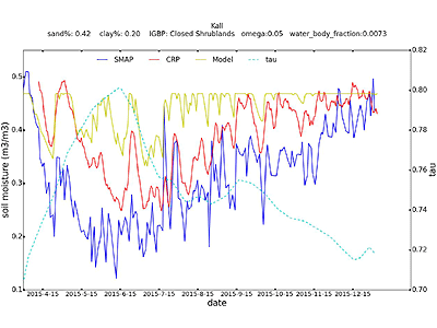
| Cosmic ray probe (CRP) site: Kall. Left y-axis is soil moisture and right y-axis is parameter tau value. Blue line is SMAP soil moisture of the grid where Kall site drops. Red line is soil moisture from CRP. Yellow line is area average of TerrSysMP model soil moisture over the SMAP grid. Light blue dash line is tau value. In the title there are properties of this site. (Please feel free to use this photo) |
By: Hongjuan Zhang
Date: 26/03/2017 - 31/05/2017
Locations: Cambridge, MA, USA
The main objective for this two-month visit was trying to integrate the SMAP-data in our model TerrSysMP. Satellite SMAP was launched in January, 2015 to measure the amount of water in the top 5 cm (2 inches) of soil everywhere on Earth’s surface and to produce global maps of surface soil moisture. In the course of its observations, SMAP will also determine if the ground is frozen or thawed in colder areas of the world. SMAP is designed to measure soil moisture over a three-year period, every 2-3 days. This permits changes, around the world, to be observed over time scales ranging from major storms to repeated measurements of changes over the seasons. The data from SMAP will help to monitor the drought, predict floods and forecast the weather condition.
During my study in MIT, I processed the SMAP data for Rur Catchment. SMAP has 4 levels of datasets with various grid resolutions. We used the level 3 data with 9km grid resolution. Firstly, I cut the SMAP data for the Rur Catchment. Then I compared the soil moisture results from cosmic ray sites, SMAP soil moisture and our TerrsSysMP model prediction. Cosmic ray probes provided point scale measurements, SMAP data was for spatial scale (9km) and TerrSysMP model was also for spatial scale (0.5km). I calculated the SMAP grids which included the cosmic ray sites, and in which model grids were averaged. Then the three types of data were compared. We found that SMAP data was generally drier than cosmic ray data (almost all cosmic ray sites, except for a forest site ‘Wildenrath’), while soil moisture from model was always over saturated.
To investigate the dry bias in SMAP data, we also put some effort on the retrieval procedures of SMAP data. Parameters omega and tau in the retrieval model were important for the soil moisture output. So we tested the two parameters to see how it affected the soil moisture output.
In the future, we will conduct joint assimilation of groundwater level data and SMAP data with TerrSysMP for the Rur Catchment and analysis of results for different simulation scenarios, and evaluation with independent data.
Co-operation partner:
Prof. Dara Entekhabi (MIT)


