Analysing the temporal and spatial dynamics of surface soil moisture using SAR data and process based modelling


Research Area:
Hydrology, Remote sensing, Pattern analysis, Crop growth, Ecohydrological modeling
|

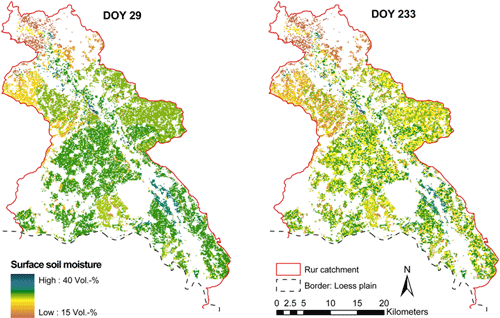
Spatial distribution of modeled surface soil moisture (top 20 cm) of crop fields in the northern part of the Rur catchment on the 29th of January (DOY 29) and the 21st of August 2009 (DOY 233).
|
Understanding the temporal and spatial patterns of soil moisture at different scales is important for applied tasks such as water and agricultural management, as well as for basic research e.g. improvement of large scale models. The general goals of the sub-project C3 are to improve our understanding of the temporal and spatial patterns of soil moisture at different scales, to diagnose the driving processes, which explain these patterns and their temporal dynamics, and to analyse the effects of soil moisture heterogeneity upon carbon and water fluxes. We pursue these goals by integrating remote sensing and process based modeling. SAR images from ERS, ENVISAT and ALOS were used in the first two phases used to derive surface soil moisture patterns. With the launch new polarimetric SAR systems from 2014 onwards, the frequency of high quality polarimetric C- and L-band SAR observations will improve strongly. The combination of the different systems will provide a repetition rate suitable (at least at times) to directly monitor the temporal development of surface soil moisture patterns. In 2015 three, from 2016 onwards four, polarimetric C-band (RADARSAT-2, SENTINEL-1 A/B) and L-band (ALOS-2, SMAP, SAOCOM A/B) systems will be in orbit. The ecohydrological model DANUBIA is used to derive vegetation status (biomass, water content in plants, phenology) for radar model inversion. Furthermore, DANUBIA is used to analyse soil moisture patterns, scaling behaviour and cause and effect relationships with respect to agricultural management, plant growth and soil moisture dynamics. Based upon these analyses and our understanding of surface soil moisture patterns and scaling properties our task will provide input to further parameterize processes in the Community Land Model (CLM) commonly used by the TR32.
Cooperation partner:
n/a